A tropical system that the National Hurricane Center is now calling Invest 91L has a high chance of soon becoming the Atlantic’s seventh named storm of the season. Some forecasters also predict it will continue strengthening into a hurricane.
The 2025 Atlantic hurricane season is experiencing an unusual post-Labor Day lull. High vertical wind shear and plenty of dry air from Saharan dust have helped quell most tropical activity originating from the African coast.
Invest 91L has managed to bear through those conditions and has shown gradual development as it now crawls westward across the central tropical Atlantic at around five to 10 mph.
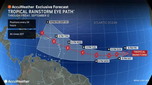
By the middle of next week, AccuWeather forecasters predict that Invest 91L will organize into Tropical Storm Gabrielle before strengthening into a hurricane before it reaches the Caribbean.
“People in the northeast Caribbean should closely monitor forecast updates,” AccuWeather Lead Hurricane Expert Alex DaSilva said. “We expect tropical storm Gabrielle to form this weekend to early next week and then strengthen to a Category 2 hurricane as it approaches the Lesser Antilles.”
What Floridians should know about Invest 99L
Where: Invest 91L is currently a broad area of low pressure that is associated with a tropical wave in the eastern tropical Atlantic. It’s located near 35W from 17N southward to 7N, which places it well over 2,000 miles southwest of Florida.
Development: The NHC says that Invest 91L is likely to form into a tropical depression by the weekend. AccuWeather forecasters believe that it will become a tropical storm by Sunday and a hurricane by Tuesday.
Path: Invest 91L is currently traveling west, and is expected to continue that path before turning northwest by early next week. It’s unclear where the storm will end up later next week, however.
Florida impacts: Forecasters aren’t sure what impacts a tropical storm or hurricane would have on the U.S. at the moment. AccuWeather predicts a low chance of tropical rain and wind impact risk throughout all of Florida and across the entire span of the U.S. Gulf and Atlantic coasts.
Understanding invests and tropical waves
Tropical waves are big ripples or waves in the atmosphere that usually occur over warm ocean water. These waves are often associated with clouds, rain and storms that they produce.
Tropical waves are important to track because 85% of all tropical storm development can be traced back to them, according to AccuWeather.
Meteorologists designate tropical waves as invests to communicate that they intend to keep a closer eye on the disturbance and will start to run models. These designations are often associated with tropical waves that end up developing into tropical storms or hurricanes, but they are not an indicator of their potential to intensify.
Potential Invest 91L impacts
The Leeward Islands and Puerto Rico are forecast to see deteriorating conditions by next week, according to AccuWeather.
“By the middle of next week, the Leeward Islands could experience deteriorating conditions from a hurricane passing close by or right over the region, including torrential rain, powerful winds and rough seas,” it wrote in its latest forecast.
AccuWeather meteorologists expect Invest 91L to strengthen into a Category 2 hurricane by the time it reaches the Caribbean, with wind speeds reaching between 100-120 mph.
It predicts that four to eight inches of rain could fall within that high wind band, with up to 12 inches possible in some areas.
Is Invest 91L heading toward Florida?
Most spaghetti models are leaning toward Invest 91L taking a path north of the Leeward Islands, but it’s still to early to know if the storm will head toward Florida.
“The strength of the Bermuda High over the central Atlantic, along with steering winds, will determine whether this system continues west toward the U.S. East Coast or turns north into the open Atlantic next week,” DaSilva said.
Spaghetti models for Invest 91L
Special note about spaghetti models: Illustrations include an array of forecast tools and models, and not all are created equal. The hurricane center uses only the top four or five highest performing models to help make its forecasts.
This article originally appeared on Pensacola News Journal: Invest 91L pegged to become the Atlantic’s second hurricane of the season

